Even today, Baler remains besieged … by weather, mountains, the biggest ocean in the world. But with weather wisdom, terrain awareness and the patience to turn back and try again another day, you can break the siege.
And remember, the Crispy Buntot is delicious.
There are three routes across the Sierra Madre mountains to Baler.
Short and Fast
Through the Bongabon-Baler pass. Short and fast. Squeeze through the gap between solid cloud above and even more solid mountains below.
[Captions available, mouse over each image.]


If the gap closes, you are suddenly flying blind below mountain peaks. The flight might get really short and fast.


Commit if you can see the coast on the far side. Then think…

… of future comments on Facebook about your pathetic genetic material, if you splatter on the mountain.
Once committed, you can’t abort. Turning or climbing blind into a lowering ceiling is Russian Roulette — high terrain all around.

You could also climb over the clouds and cross at 7,500 or 9,500 feet. But unless you’re flying a MiG, towering Cu can build faster than your airplane can climb.
The Scenic Route
Through the Pantabangan river valley, to Baler’s coastal plain. Lower mountains, higher ceilings … and more traffic. I once zipped by a Cessna 172 here, opposite heading. No radio contact. Hard to spot, see below:

You can do something here that you can’t do in the mountain passes. You can turn around.
The End-Around
Southeast through Laur valley to Dingalan Bay on the Pacific Ocean, then up the Aurora coastline north to Baler. Big detour.

You’ll burn a lot of fuel.
Past the mountains, a magnificent coastal plain opens up. The airport is invisible until you are close in.


On the ground, you keep one eye on the sky, one eye on the clouds, and one eye on the mountains, lest they move towards each other and ruin your day.


Sierra Madre weather factory. Gap between cloud and mountain at left where we flew through.
Last February 28, Carlo climbed us to 9,200 feet, trying to beat the clouds. We just couldn’t out-climb the weather, and suddenly we were boxed in, cumulus towers all around us.
Energy similar to a thermonuclear detonation had lifted millions of tons of moisture into white cotton skyscrapers. They could flip upside down in unplanned aerobatics over forested mountains. Without wings.
We anxiously turned in a big circle, besieged by silent, lethal white monsters reaching thousands of feet above us. I banked steeply through a gap, seeing green fields of central Luzon far ahead. We fled, just 11 nautical miles from Baler airport.

I put the airplane in a dive, northwest to the Pantabangan reservoir, to try again. Traced the river east. Down low now. Dark. Rain. Darker. Clouds.
Hopeless.
Carlo turned us around under a ceiling barely 1,000 feet AGL. Mist, drizzle, low visibility. We were only 15 nautical miles from Baler.

(Five weeks later, we retraced the old GPS track and took pictures of where we turned back. You can even practice your flight on Google Earth.)


We were way down deep in that valley, that day we turned back. Except that the visibility was 20 times less.

Going home, picturesque Pantabangan sprawled below us, that damn eagle at our 8 o’clock high making sure we were bugging out.

On the rice paddies, the wind rippled silver sheets of water under the rice crop. Impossible to photograph, and only a pilot, and God, can see that.
Even when you can’t break the weather siege, Baler is beautiful, coming or going. I am torn between raving about Baler, and keeping it secret.

Posted from Bangkok, August 28, 2009.
Carlo’s Birthday. Happy Birthday, Carl!!


.
.


 The movie Baler! was sweeping awards at the Manila Film Festival.


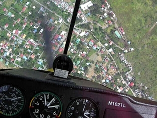
 Carlo and I made it to Baler for the first time in May, 2008. I can’t recall how we crossed the mountains, but it must have been hairy, because this awesome cellphone photo is from that flight.

 We flew into the airport, eight kilometers inland from the Pacific coast.