Remember your childhood backyard? You knew where every tree was — the guava in the corner, the macopa near the poso, three kaimito dominating the center. The dwarf lived under the culvert, and the sweetest aratilis grew over the neighbor’s wall.
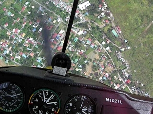
Carlo and I learned to fly over Central Luzon. In the lazy summer heat, we smelled the parched rice fields even from 1,500 feet. When we banked steeply over the twisting Pampanga river, the fishermen in the bancas waved.
 Our backyard. With no pilotage chart or GPS, we can find the prison camp from the Great Raid.
Or the footbridges and weirs on the Pampanga river, the lake near Cuyapo that swallowed a town, where the dwende lives, where the sweetest aratilis are.
Last week we flew for the first time in weeks. Straight up Central Luzon to the San Roque dam.
In the aftermath of super typhoons Ondoy and Pepang, nothing was recognizable. If not for the GPS, I would have been lost.
This used to be a sitio of Concepcion, Tarlac. North of the Sacobia River, west of the Rio Chico.

A little further north, a soggy chicken farm collapses into the muck.

On our cross-country training flights, we flew legs from Concepcion, Tarlac, to Zaragosa, Nueva Ecija. Careless compass work would take us to La Paz, instead. We soon learned to recognize and use La Paz to check our course.
My GPS now said this was La Paz. I couldn’t tell.


See the flood current, streaming across the Zaragosa highway? Imagine your house shuddering in that current. For a week.

There is a long grass airstrip at Paniqui, Tarlac. Good drainage all around.
We flew over it just 6 weeks ago, on Carlo’s birthday, and took this picture. A place to land if our engine decides to take a break.
You would need amphibious floats to land at Paniqui now.

At Ramos, the next town east, the rice fields were gone. The forked road in the town center looked like twin tributaries. No help could come up that submerged highway from Paniqui.


Rolf’s grass airstrip at Nampicuan was also flooded. Rolf, who moved here from Europe because he loves the Philippines, plans to introduce sailplane soaring in the country.

I don’t know if his sailplanes, and the D4 Fascination, were in the hangar.
At Rosales, site of an old airfield dating to WWII, the Agno River breached the dike and flooded the town to the second floor of that new SM mall nearby.


The flood had drained back into the river, but the airstrip was muddied and still flooded at the western end.
I followed the Agno river east and then north. Flirting with the Cordilleras now, I switched the GPS to terrain mode. I strained through the heavy haze to see the mountains which I knew were close by.
I knew what I was about to see, but the sight was still riveting.
The San Roque dam was releasing water through two open flood gates.

I’m an engineer. In 1978, during Martial Law, I wrote an article in the UP Collegian about Angat dam releasing water during a typhoon, wreaking havoc on Bulacan and Manila. The government threatened me for that, even if I just quoted reports from the crony press.
Suing a dam operator is the most non-constructive step now. When we run out of hydroelectric power and irrigation water next summer, the engineers with the solutions will be in jail. Or in Qatar.
No, the sordid origins of this mad-made catastrophe lie far upstream of Carlo’s generation.
I flew home, rain clouds drawing dark drapes across our beloved backyard.

Posted from Bangkok, October 17, 2009
.

Looks a bit different than before!
Need to go up next sunday to have a look!
LikeLike
my, oh my tonet… didn’t think it was this worse……..=0( only started really realizing it when i attempted to buy veggies yesterday and it was horrifyingly expensive?!?! imagine, a small head of cabbage now costs 100.00 when it was only 50.00 2 weeks ago – but bigger?!?! and then i started thinking about what happened to them…and then saw these pics…….. thanks for sharing.
LikeLike
We heard of these floods and storms in the news over-here in France.
We do have floods here too but nothing as big as what you may be experiencing!…
LikeLike
Kisset, thanks for visiting Flying in Crosswinds. Yes, the rural folk have the toughest time recovering. The rice fields were just a couple of weeks from harvest. Now farmers must start over, and can’t replant until the fields are cleared of silt
Going to Baguio, we cross one last long bridge, then stop at the Shell station at Sison — last bathroom and snack stop before the old toll booth at Kennon Road. Remember? That bridge is the Bued bridge (Kennon road follows the Bued river gorge all the way to Baguio).
The Bued bridge is now broken in mid-span. It is the only way to go by road from La Union, Ilocos and the Cordillera Admin Region down to Pangasinan and the rest of Central Luzon. Manila is now cut off from the vegetable crop in the north. Think about it — the vegetable plots in Tagaytay are small, mostly hobby farms. Everything south of Manila is coconut and sugar. The real food comes from northern and central Luzon. All devastated.
And nothing can drive down those highways for a while.
Pat, thanks for your concern. We have had floods and typhoons every year for the past 100 or so years. And yet our government has failed to invest in a credible and reliable flood control program. It is posible to harness nature while living in harmony with it. But we have not learned this yet.
Timo, I wish we could help more, somehow. I flew low over the few town centers and all the schools were deserted. It’s not just the damage — the recovery and reconstruction can’t even start yet, and we are losing time in educating our future — the kids.
.
LikeLike
Hi Tonet,
It’s been a while since I read your blog (fishermen in San Juan La Union)
That’s a lot of devastation caused by the typhoons and the dam. Hopefully, things will get better in the near future for our fellow Filipinos. I think there are other highways between La Union and Pangasinan other than the Bued. This might ease the flow of food and equipment intra provinces.
Keep doing what you do. Maybe someday we can ride your plane.
Are you on facebook? Drop me an email.
Take care,
Man
LikeLike
Hi, yes, I am on fb.
Yeah, the routes through San Fabian and La Union are still open, but sporadically and very constricted. As you say, things will get better. The challenge is to accelerate recovery and prevent recurrence. That can only be done with enlightened, sincere leadership.
Riding the airplane — sure! Weather permitting… 🙂
Stay in touch and visit the blog again.
LikeLike
On the one hand, this country is so full of wonders.
On the other hand, it’s also very good at destroying what is good, true, and beautiful.
It’s tough for someone in my generation to grow up believing in his own country.
LikeLike
The particular airstrip in paniqui owned by cojuanco family, the daughter-in-law the owner is former president Corey Aquino, she was born in paniqui their ancestral home is there near the airstrip , I would like to know about anao airstrip because I am pilot stranded in paniqui, if I have any opportunity to still fly, paniqui is just near anao, do you have any contacts of airstrip management or owner there ? 2008 my last flight because of cheated,
LikeLike
Sorry daughter not daughter in law
LikeLike