Our last Adventure article introduced a visual treat — touring Central Luzon in a flying soda can. We continue our aerial Backyard Tour. An emergency airstrip, and a mysterious lake.
East of Lingayen Gulf are the Cordilleras, and the Cordillera Autonomous Region. Baguio, Sagada, and Banaue all lie in that direction, as does the highest peak in Luzon, Mt. Pulog.
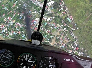
The Bued river, below, separates Sison from Rosario.

The bridge between the towns is the gateway to Kennon Road, the popular road to the cool mountain retreat of Baguio City. The scenic gorge that Kennon road follows, all the way to the Baguio plateau, is this same Bued river.
When I was a child we went to Baguio twice a year, the Filipino’s equivalent of a vacation in the Swiss Alps 🙂 Crossing this bridge between Rosario and Sison got everyone in the car excited. We pretended that we would be climbing the “Alps”. [More on Baguio in a future article.]
South of Rosario are the twin towns of Villasis and Carmen. Beside Carmen on the big Agno river is Rosales.

Rosales has a serviceable emergency airstrip. Carlo and I always overfly Rosales, on the way to and from Baguio, because it’s a place to land if the engine goes to sleep.

The town is growing, but they keep that airstrip free of structures. Lots of paths criss-cross it. Probably a great biking and kite-flying spot.
 Rosales was an American auxiliary airfield in the early days of World War II. Surviving P-40 fighters took refuge here when Clark and Iba airfields were wiped out by attacking Japanese bombers on December 8, 1941.
Lingayen also was an auxiliary field. One P-40 landed there on December 8. The pilot drove all night in a borrowed car to Rosales for fuel. He drove back to Lingayen with drums, and refueled his P-40 by hand.
Then he crashed on takeoff. After all that labor.
He bequeathed his airplane’s machine guns to the local army detachment and went off to find the rest of the war. A couple of weeks later the Japanese landed at Lingayen. Presumably the machine guns were put to some use.
Up in the northeast corner of the Central Luzon plain, in the tri-provinical boundary of Benguet, Pangasinan and Nueva Ecija, lies the municipality of Cuyapo. Apolinario Mabini was found and arrested by the Americans here, during the “Philippine insurrection” in December 1899.
Near the municipality is a strange lake, looking like a shallow dish on the ground.

We’ve always wondered what the story of this lake is. Maybe someone will post a comment on it?

Wilfredo Pascual’s fascinating blog, Secret Gospels, Sacred Sites, mentions a cursed mystical lake linked to a tragic story dating back 3 centuries. Perhaps this is Paitan or Libsong, the morass that swallowed an entire Spanish church and town?
Next on the tour — Nueva Ecija, Pampanga, Bulacan, Hukbalahap country and every pilot’s top secret method for not getting lost!
.

hi!! I really like your blog. I have asked my blog buddies to check out your blog! The pictures are really great..good work!
LikeLike
Hi childwoman! Welcome to Flying in Crosswinds.
We have literally thousands of pictures of flying around this country, and the people, and the places.
I saw your note to your blog buddies. The world wide web is truly magical, isn’t it?
Tell me about the rain cloud that seems to be following you around, in your avatar 🙂
Thanks for your note.
.
LikeLike
Hi there! Found the blog through Childwomen, hehe. Beautiful pictures!!
Questions: have you even flown over Niger before?
Ishtar
LikeLike
hi. many thanks for the link to my blog. thank you for the aerial image, would love to have your picture featured in my blog too (if that’s ok), along with the story i researched about the lake.
Wilfredo
LikeLike
Hi Wilfredo, thanks for dropping by here.
Sure, please go ahead and use the photo. I believe you can right-click then save it to your computer. I took the photo while flying alone over Cuyapo on May 12 of this year.
I look forward to learning more from your research about this strange-looking lake!
LikeLike
Congratulations to Wilfredo Pascual for winning First Place in Essay, in the 2007 Carlos Palanca Memorial awards for literature. I have the highest respect for Palanca award winners. They are chosen from among tens of thousands!
Wilfredo’s blog can be found at
http://www.personalwilli.blogspot.com/
LikeLike
Sir nice pictures! Thank you for posting wonderful insights and facts about a certain place. By the way sir, Carmen is a barangay of Rosales municipality. During my childhood days, my mom used to bring me along with her to visit our relatives in Rosales, and Carmen is the place where most establishments are located where we eat. Until now, Brgy Carmen, I think is more progressive than the town of Rosales itself. Keep it up sir…God bless. Fly safe!
LikeLike
Hi Dencio, thanks for visiting Flying in Crosswinds, and for leaving a comment.
I’ve always wondered, is Carmen Rosales, the actress, named after Carmen in Rosales?
Do you live in Carmen, sir? I am about to write about old airfields in Luzon, and Rosales is one of the oldest.
Thanks again for visiting, and do come back here soon!
.
LikeLike
Hi kabayan. My name is “ka romy”. I was born in Rosales Pangasina on Oct. 27, 1941, graduated high school at the Pangasinan School of Technology, formerly located the back portion of Rosales Public Market. Later on, towards the end of the 1950’s my parents had opted to transfer residence at Cuyapo Nueva Ecija, adjacent town of Rosales. At present, I have a 2-hectare mango farm in Brgy Paitan Norte in Cuyapo where the said “lake” or Libsong is located. As a bird’s eye view about this wonderfull “lake” — this is bounded or surrounded by three barangays namely Paitan Norte, Paitan Sur and Nagcuralan.Officially, as can be verified in our Philippine map, this “lake” is known as ‘PAITAN LAKE’ — the reason being that more than 80% of its water area belongs to or is within the territorial jurisdiction of Brgy Paitan Norte.
There was a time when I made an attempt to write about the myth that sorrounds the legend of Libsong or Paitan Lake. Certainly therefore, I can help in your desire to be enlightened, including that of the others, about the said “lake”. Hope you can cooment on this.
LikeLike
Hi Romy, welcome to Flying in Crosswinds. Sure, I would like to know more about Libsong/Paitan Lake. I have flown over it many times, and find it very strange, perfectly round, like a shallow scoop skimmed topsoil out of the ground. You know those scoops that taho vendors use?
Would you like to write a short article here about the lake? I know a lot of readers and fellow pilots have asked me about this place.
LikeLike
The like might be a Maar. There are few volcanoes (e.g. Mt. Balungao, Mt. Amorong, Mt. Bangkay, Mt. Bulaylay and Mt. Cuyapo) rising up from the central plains of Pangasinan and Nueva Ecija within the vicinity of Lake Paitan
LikeLike
[…] the footbridges and weirs on the Pampanga river, the lake near Cuyapo that swallowed an entire town, where the dwende lives, where the sweetest aratilis […]
LikeLike