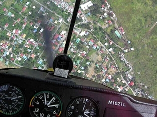
No, there are no more flying pictures of Angelina Jolie in this article! But we’ve had three pieces now on instrument flying. We do need some visual relief.
In May, Carlo and I flew VFR around Central Luzon. Carlo calls this area, “Our backyard.” Carlo and I have flown over the great plain so often, on the way to Baguio, La Union, Lingayen or Ilocos. You could blindfold and fly us to any point here, and we could fly our way home. No chart, no GPS.
Pangasinan province is a good place to start — my Mom comes from there.
Alaminos, Pangasinan. Many think that Alaminos is synonymous with the Hundred Islands.

Actually, seen from the air, Alaminos is far inland. The town where you embark for the Hundred Islands is Lucap, Pangasinan.
We’ve flown over the Hundred Islands several times, both high and low.

Some islands have been linked with barriers, turning the erstwhile scenic clusters into one gigantic fish trap. Geez!

The Pangasinan coastline south of the islands is beautiful, if not often extolled.

There are bays and coves that could be great dive spots, with underwater coral ledges and walls clearly revealed by our aerial reconnaissance. And we were 5,500 feet high!

At Sual, Pangasinan, there is a coal-fired power generation plant with a bizarre claim to fame.

On December 10 (my Mom’s birthday!), 1999, “50 truckloads of dikya were sucked into the plant’s cooling water system”. The plant ground to a halt, and the failure cascaded catastrophically throughout the entire Luzon grid, resulting in a complete power blackout in half of the country!
A fishy story.
Maybe that’s why they penned the Hundred Islands? To keep the loathsome dikya out (or in?).

You can see more monster dikya attacking from the right!
My Mom hails from Mabini, Pangasinan.

Mabini is also the site of the Malaysian Proton car plant, on the upper left corner of the photo. It was seduced away from the other car assembly plants in Southern Luzon by former President Ramos. 😛 I don’t know if it is in production still.
Lingayen Gulf, bounded by the curving Pangasinan and La Union coastlines, has its own claim to fame. The Japanese landed here in December 1941 and charged rapidly down Central Luzon to capture Manila.

Central Luzon is a great, flat plain, with few natural defensive obstacles to an invader, except for the rivers. There is a thrilling war story, for example, about the Calumpit bridge near Baliuag and Plaridel in December 1941. We will keep that for another article.
So invading at Lingayen and advancing straight down to Manila was an obvious tactic in World War II.
Thus, the Americans also landed in Lingayen Gulf in 1945, to begin the liberation of Luzon. There’s a great chart of the amphibious landing here, from an outstanding website on the US Army campaign in the Philippines, by Robert Ross Smith.
The US Sixth Army landed near San Fabian, here where the coastline curves upward from Pangasinan to La Union in northern Luzon.

They, too, swept down the length of the Central Luzon plain towards Manila. In fact, the “MacArthur Highway” is so named because it follows the route taken by the Big Red One, the 1st Infantry Division, as it charged in a “flying column” towards the capital city.
There was not much in the way of their charging, since the Japanese had decided on a defensive stand in the Cordillera mountains. This left the way open to Manila, which the Japanese, like MacArthur 3 years earlier, did not plan to defend.
But then the Japanese Navy decided to fill in the vaccum, and Japanese Marines fortified Manila, which became the second most destroyed city in the second world war. More people died in the battle for Manila than died in the atomic bombing of Hiroshima.
Along the way from Lingayen to Manila, the Americans raided the prison camp near Cabanatuan and freed the American prisoners who had survived since the fall of Bataan and Corregidor, 3 years earlier. That too, will be a separate article, with aerial photos!
If you click on the link to the chart, you will see that the “Airfield” near Lingayen is still the site of Lingayen Airport today, where Carlo flew his first solo cross-country.

The airport is a good challenge because of stiff crosswinds and some wind shear, and is nearly 60 nautical miles from Omni. So it’s a perfect cross-country training destination for student pilots going through the private pilot course.

The northern reaches of Central Luzon are beautiful, despite the coal-fired power plants and the man-made fish pens around the Hundred Islands. The overall impression is of a scenic, lazy backyard, with little habitats here and there. Like a backyard, it is full of summer vacation memories.
To be continued! 🙂
Next week, touring more of Central Luzon by air — Nueva Ecija, Pampanga and Bulacan.

.

Haha, having learned to fly in Omni, I feel it’s my “backyard” too! (‘Backyard’… I like that term..)
I’ve always admired those sights each (and every)time I fly there, but learning a little history behind those places makes me realize how shallow my admiration for them is. Great pics, cool tidbits. Keep it coming please : )
LikeLike
Remember how you used to know every tree, every anthill, every different smell in your backyard? Where the water runs after every summer rain storm, where the shades are coolest in summer?
There’s so much to write, about flying in Luzon. The beaches of La Union, the mountains at Baguio. We will see more of our backyard, in this blog, for sure.
Thanks for your note!
.
LikeLike
I am really glad to view my hometown on the sky, I congratulate your excellent idea and views. About Proton on your comment for Mabini, its no longer operational after some unit production. Would you pls. include on your next feature pictures for Alaminos City, Tagudin Mabini School, Labrador area and other Western Pangasinan area
Best Regard and Good Luck
LikeLike
Hi Sean, thanks for dropping by the blog. I am traveling on business right now, and when I have another chance to fly over Luzon I will certainly try to take pictures of Alaminos.
Not sure if I can find the school 🙂 but I think I know where Tagudin is, so… .
Keep watching the blog for more Luzon pictures!
.
LikeLike
thanks guys, I really enjoyed identifying several familiar landmarks from your pictures. And I always thought that Alaminos is beautiful, now I believe that it is more beautiful. 🙂
LikeLike
Hi Che, thanks for visiting Flying in Crosswinds, and thanks for taking the time to write a note.
We have lots more aerial pictures of the Alaminos/Lucap/Lingayen area. If you let me know exactly what you are looking for I might find it in our archived images. We only post a very tiny fraction of the hundreds of aerial images we take.
Thanks again for writing a note 🙂
LikeLike
You have great pictures of our Province. I would like to ask you, if i could share this picture to the Governor to show the great potential of our Province. The beauty of the land, the historical background and the abundance of marine life are just few of the assets for a world class province. The strategic location to Hong Kong making it another great Destination for the tourism and investment which will help the economy of our province. If you will, probably you could share more insights seem you know a lot!
thank you i hope you could help us making Pangasinan a Great Destination, The Heartland of the Philippines.
LikeLike
Hi Joel,
Thanks for visiting Flying in Crosswinds!
Sure, please go ahead and share the pictures with the Governor, and credit Carlo with them, since he took many of these pictures.
I love flying over Pangasinan. There are a lot of picturesque spots, and the airfield at Lingayen is a historical site, as well as the site of my first cross-country solo flight!
.
LikeLike
Thank you very much for your quick response, I know pangasinan is a Province that is not so Advertised and Marketed.
Where did you fly from? How far flying time is it from Manila. Do you think the airport right now could accomodate small commercial plane. My client is the Largest Cessna dealer if theres anything i could help you with, just let me know.Could we fly and rent a plane to go to Pangasinan? How much it would cost. Pardon me for all the questions, because I need to know these questions when they asked me.
LikeLike
dear joel tukayo
i am from the very beautiful coastal town of sual
i share with you all the good visions for this wonderful
province, i also used to worked in urduja
at the PIO Governors Office
hope we can chat sometime
tonet – great pictures of sual and hundred islands.
looking forward of seeing more in the future bro!
best regards to all
LikeLike
Hi Joel, welcome to Flying in Crosswinds. My Mom is from Mabini, Pangasinan, and I have always thought that Pangasinan is one of the most photogenic provinces for aerial photography (but I might be biased! 😀 ).
On the other hand, Ilocos, Aurora, Zambales, Benguet, Pampanga and Nueva Ecija are all just as beautiful. In other words, I yet have to see any part of the Philippines that isn’t beautiful from the air. I sincerely mean that — this country, when you soar above the asinine and imbecile politics and climb away from the pollution, bureaucracy and squalor of Manila, is inherently beautiful.
But that’s what everyone says about it anyway, right?
Will post a lot more pictures as I fly over more of the country, and as I begin to recover from the theft of my digital albums.
.
LikeLike
i’m from cagayan valley and i hope you could also visit our place.
hope to view also some images seen in our place!
LikeLike
Great images, this will help to boost tourism in my town Alaminos and nearby towns like Mabini, hope you can include areal views of Bani and Bolinao. Keep up!
LikeLike